【題目】青稞主要分布在海拔較低的河谷地帶,反映出西藏自然環境特征是()
A. 濕熱 B. 干旱 C. 高寒 D. 多雨
 閱讀快車系列答案
科目:初中地理 來源: 題型:
【題目】
The rockets take astronauts and man-made satellites into space. The satellites are used for communication, weather monitoring and research. But how do satellites stay up without Falling down?
There are two opposite forces acting on the satellite. One of them is the force of gravitation(地心引力), which tries to pull the satellite toward the earth. The other force is created by the rotation (旋轉)of the satellite around the earth. This force tries to take the satellite away from the earth. With these two forces, the satellite goes round and round. The gravitational pull of the earth is like a rope which keeps the satellite from flying away.
Everything that goes up has to come down. It is only a matter of time before a satellite comes back to the earth. As time goes by, the satellite loses its speed, which makes the gravitational pull stronger than the force pulling it away. This makes the satellite crash (墜落)down to the earth.
【1】The force that pulls the satellite towards the earth is created by ________.
A. the earthB. the satellite itself
C. the rotation of the satelliteD. the rope
【2】Why can't the satellites fly away?
A. Because of the force from the earth.
B. Because the satellite is too big.
C. Because of the force created by the rotation of the satellite around the earth.
D. Because people on earth have made ropes to tie the satellites tightly.
【3】Which of the following is TRUE according to the passage?
A. There are four forces acting on the satellite.
B. The force of gravitation makes the satellite go round and round.
C. As time goes by, the satellite will finally fall down.
D. The satellite will stay in space forever.
查看答案和解析>>
科目:初中地理 來源: 題型:
【題目】讀某地等高線地形圖,完成下面小題。
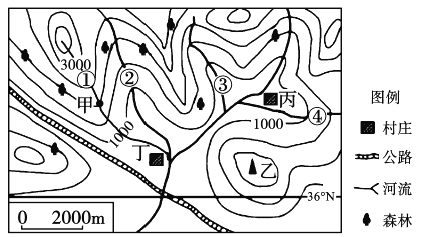
【1】下列判斷正確的是( )
A. 甲位于山谷 B. 乙為山頂 C. 該地為丘陵地區 D. 甲、乙兩地間相對高度大于500米
【2】圖中標出的幾條支流中,有一條實際上是不存在的,其序號是( )
A. ① B. ② C. ③ D. ④
【3】關于丙、丁兩村的比較,正確的是( )
A. 丙村交通更為便利 B. 丙村水源更為豐富
C. 丁村位于丙村的西南方向 D. 兩村都不可能發生滑坡災害
查看答案和解析>>
科目:初中地理 來源: 題型:
【題目】讀我國局部地區地形示意圖,完成下列要求。
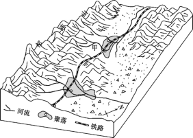
(1)圖中聚落所在省區的簡稱是____,導致兩個聚落規模不同的主要因素是______。
(2)圖中鐵路的走向大致是_______,影響該鐵路走向的主要因素有___。
(3)甲處建有一個水庫,庫區的最高水位一般出現在___(季節)。
查看答案和解析>>
科目:初中地理 來源: 題型:
【題目】地中海沿岸的氣候特點是( )
A.冬季干燥少雨,夏季溫和多雨
B.冬季溫和多雨,夏季干燥少雨
C.春季炎熱高溫,夏季多雨濕潤
D.秋季溫和多雨,冬季干燥少雨
查看答案和解析>>
科目:初中地理 來源: 題型:
【題目】印度是發展中的工農業大國。結合下圖,完成下列問題。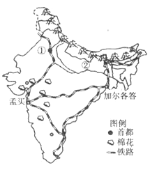
(1)填出圖中數碼所代表的地理事物。
首都:①;河流:②。
(2)印度的主要糧食作物是和。
(3)印度大部分地區每年的6~9月盛行季風,降水較多。
(4)孟買是印度的棉紡織工業中心,其棉紡織工業發展的有利條件有哪些?(從原料、交通等方面分析)
(5)印度人口眾多且增長快,會給該國資源和環境帶來哪些問題?
查看答案和解析>>
科目:初中地理 來源: 題型:
【題目】到東南亞新馬泰等國家去旅游,既要領略熱帶雨林氣候又要領略熱帶季風氣候,你要去的國家是:( )
A. 泰國 B. 新加坡 C. 馬來西亞 D. 緬甸
查看答案和解析>>
科目:初中地理 來源: 題型:
【題目】我國在南極已經建成長城站、中山站、昆侖站和泰山站,泰山站的房屋采用圓環形外表、碟形結構和高架設計(如下圖)。讀圖,回答下列各題。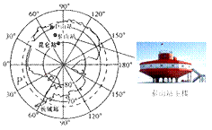
(1)四個科學考察站緯度位置最高的是( )
A.長城站
B.中山站
C.昆侖站
D.泰山站
(2)下列哪一個不是泰山站主樓建筑架空離地設計的考慮因素?( )
A.防御野獸侵襲
B.防寒保暖
C.防積雪融水進入
D.防大風積雪掩埋
(3)圖中P處位于( )
A.太平洋
B.印度洋
C.北冰洋
D.大西洋
查看答案和解析>>
湖北省互聯網違法和不良信息舉報平臺 | 網上有害信息舉報專區 | 電信詐騙舉報專區 | 涉歷史虛無主義有害信息舉報專區 | 涉企侵權舉報專區
違法和不良信息舉報電話:027-86699610 舉報郵箱:58377363@163.com
