【題目】讀圖“我國溫度帶劃分”圖,回答下列問題。
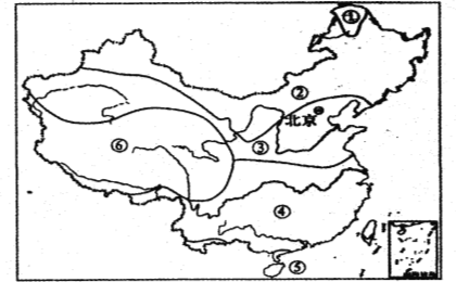
(1)填出圖中數字所代表的溫度帶名稱:① , ⑥_____________。
(2)按溫度帶劃分,中山市位于 帶,作物熟制______________。
(3)圖中溫度帶③和④的分界線大致經過 ,和我國一月的 等溫線分布基本一致,與年降水量 毫米等降水量線分布基本一致。此線以北的糧食作物是 ,此線以南人們的主食是 。
科目:初中地理 來源: 題型:
【題目】讀“我國政區圖”,回答問題。(9分)

(1)字母表示的省區:A ,B ,C ,D 。
(2)字母表示的省區的簡稱:B , C 。
(3)B省主要的少數民族是 族。
(4)字母表示的省區的行政中心:D ,E 。
查看答案和解析>>
科目:初中地理 來源: 題型:
【題目】讀下圖完成下列問題:

(1)1省的名稱________、簡稱________、行政中心_________。
(2)2省的名稱__________、簡稱_____________、行政中心_________。
(3)3省的名稱__________、簡稱_____________、行政中心_________。
(4)4省的名稱__________、簡稱_____________、行政中心_________。
(5)5省的名稱__________、簡稱_____________、行政中心_________。
(6)6省的名稱__________、簡稱_____________、行政中心_________。
查看答案和解析>>
科目:初中地理 來源: 題型:
【題目】【2016湖北宜昌】閱讀理解。
My house is on a hill. There was only a small parking place. As a new driver, I was so scared when I realized I would have to reverse(倒車)out of the driveway. I knew that if I parked backwards(朝后), it would be easier to get out later. 【1】.
For three months, I didn’t even think of trying. 【2】 . But one day, I suddenly thought to myself, “How am I ever going to know whether I can do it if I don’t even try?”
So I started my car, went down that hill, turned around and reversed. I made it. I got into the parking place. 【3】 .
As weeks went on, I continued trying. The more I practiced, the better I did. But I had never practiced parking in the dark before. Then I decided to push myself. 【4】.
When I slowly drove to the parking place, I couldn’t see anything. My heart was beating rapidly. A moment later I guessed I was getting somewhere, I let the car go. Oh, my god! The car hit a tree. 【5】. But I tried it after all.

查看答案和解析>>
科目:初中地理 來源: 題型:
【題目】【2016江蘇南通】請根據句意從方框中選擇合適的單詞,并用其適當形式填空,使句子通順。
![]()
【1】To tell you the ,I’m afraid to see him.
【2】My bag is full. Put your books in .
【3】The students are having a hot about their future plans.
【4】On her day in Guilin,Melissa took a boat trip along the Lijiang River.
【5】—I hear there are many clubs in your school. —Exactly. Our school life is really .
查看答案和解析>>
科目:初中地理 來源: 題型:
【題目】(福建省三明市2015年中考地理試題)2015 年5 月18 日起, 三明市連續幾日普降暴雨。 圖為三明各類地形面積比例圖。據此回答下列問題。

【1】三明的地形類型( )
A. 以丘陵、盆地為主 B. 以平原、盆地為主
C. 以山地、平原為主 D. 以山地、丘陵為主
【2】連降暴雨給三明帶來的自然災害可能有( )
① 干旱 ② 洪澇 ③ 寒潮 ④ 滑坡
A. ①④ B. ②④ C. ②③ D. ③④
查看答案和解析>>
科目:初中地理 來源: 題型:
【題目】
![]()
Lost time is never found again. This is something which I 【1】 very clearly last term.I spent so much time playing computer games or hanging out with my friends 【2】my grades began to suffer.I finally realized that 【3】 had to be done. It was time for a change.
Now I have a new plan for using my time 【4】.I have set my alarm clock ahead half an hour.This will give me a head start on the day. I have also decided to make a list of what I do and when I do it.【5】 back on what I've done will give me some ideas on how to reorganize my time.
查看答案和解析>>
科目:初中地理 來源: 題型:
【題目】讀下圖,回答下列問題。( 11分)

(1)寫出圖中代號所代表的大洲:① _________④ __________
(2)寫出圖中字母所代表的大洋名稱:A______ C______
(3)從圖中可知, 赤道穿過大陸是________和________。(填數字代號)
(4)七大洲中,面積最大的是(填數字代號)_________;
(5)四大洋中面積最小的是(填字母)_________;
(6)①、③兩個大洲的分界線是(填名稱)___________ 運河;
(7)兩個圖分別表示東西兩個半球,左圖為 半球,右圖為 半球,
查看答案和解析>>
科目:初中地理 來源: 題型:
【題目】讀下圖回答問題。(12分)

(1)請將圖中數字所代表的大洲的名稱填寫在相應橫線上。
① ____________③__________⑤____________
(2)請將圖中字母所代表的大洋的名稱填寫在相應橫線上。
C________________ D_____________
(3)從南北半球來看,海洋面積廣闊的是____________。
(4)⑤洲和③洲分界線是_______________。
(5)被赤道穿過的大洋有____________、___________、__________(填寫字母)。
(6)中國位于_____________半球和_____________半球。
查看答案和解析>>
湖北省互聯網違法和不良信息舉報平臺 | 網上有害信息舉報專區 | 電信詐騙舉報專區 | 涉歷史虛無主義有害信息舉報專區 | 涉企侵權舉報專區
違法和不良信息舉報電話:027-86699610 舉報郵箱:58377363@163.com
